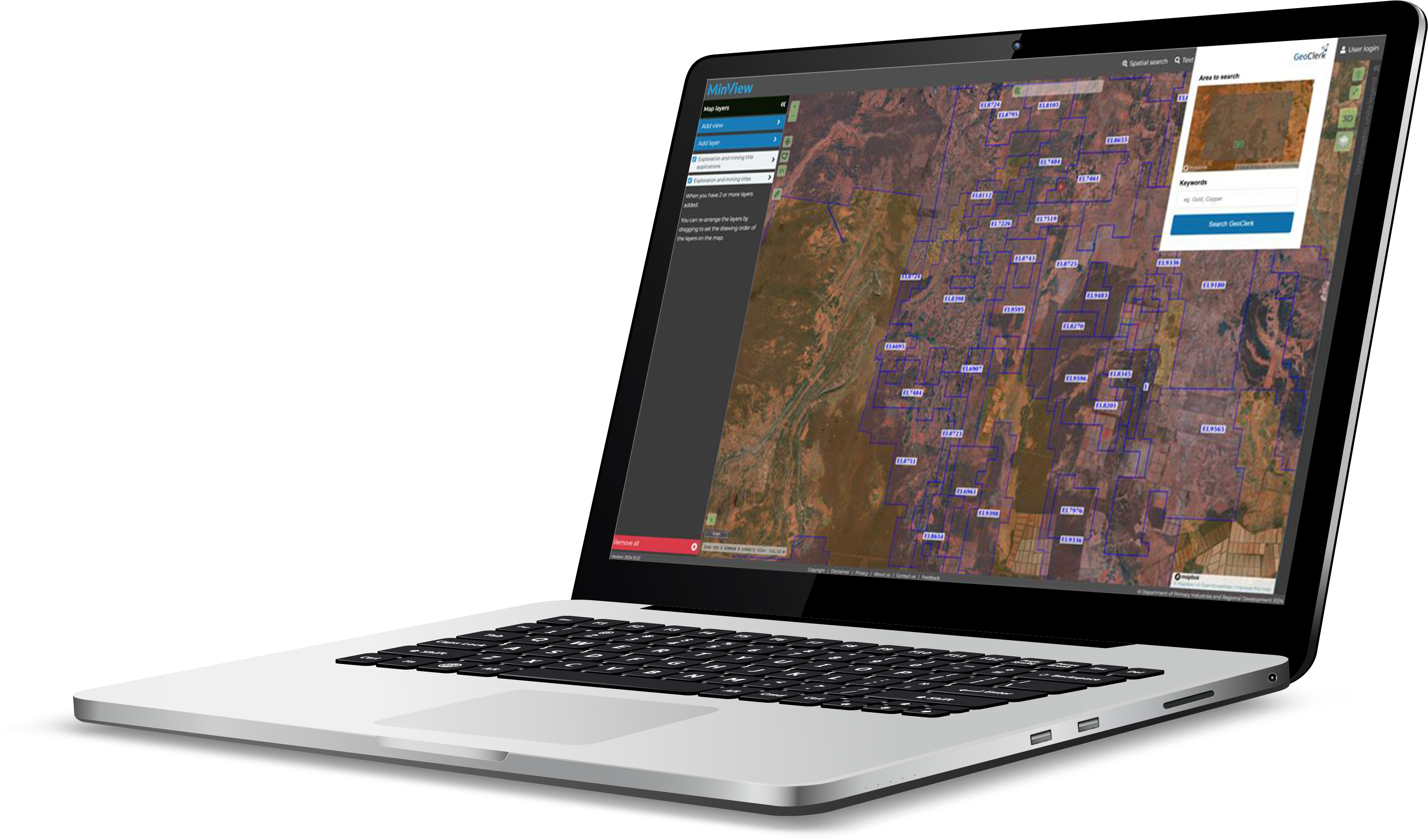
The advanced geoscience information suite
Search with the Clerk
Unlock a wealth of valuable, industry relevant geoscience information.
Advanced AI Technology
Advanced algorithms turn unstructured documents into searchable and filterable libraries and state-of-the-art generative AI enables full interrogation.
Personalise Your Experience
Georeference images, create sharable projects and set up alerts so you never miss important new information.
Limitless Search
Search through a limitless database of public and private geoscience content, and web search.
![AdobeStock_432829867 [Converted]](https://www.geoclerk.com/wp-content/uploads/2024/12/AdobeStock_432829867-Converted.png)
What is GeoClerk?
The advanced geoscience information suite
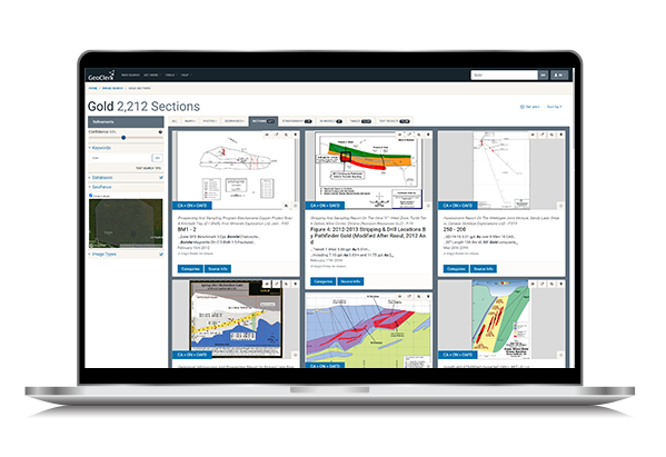
GeoClerk revolutionizes access to geoscience information by uncovering valuable insights hidden in legacy publications and unstructured documents. It automatically classifies and extracts imagery and pertinent data, performs OCR on all the text, potentially including private document databases, and organises this into searchable, filterable geo-imagery and textual libraries for convenient access.
Users can access a vast array of geoscience visuals—maps, cross-sections, 3D models, lithostratigraphic diagrams, geophysical datasets, data tables and much more—sourced from websites, presentations, reports, and scanned documents. The subscription-based platform centralises this growing, continuously updated library, ensuring users stay informed about the latest publications and discoveries.
Beyond imagery, GeoClerk has expanded to offer full-text search capabilities, streamlined georeferencing tools for maps and geophysical images, and integration of near real-time ASX and TSX news feeds. At the forefront of its evolution is GeoBot, a user-friendly generative AI tool that enables in-depth document analysis, interrogation and rapid information retrieval. GeoClerk is an indispensable geoscience information suite, empowering professionals in resource exploration and beyond to make faster, better-informed decisions.
Features
In the age of AI and machine learning, GeoClerk, brings a revolutionary approach to the resources industry, bringing to light decades of historic and up-to-the-minute uncategorised documents, making them readily accessible and available to all in one searchable location. Users will be able to effectively research and simplify efforts required to source industry relevant information.
Generate Heatmaps from Search Results
By searching all documents across one or more jurisdictions, GeoClerk is able to build up a heatmap from the results, highlighting areas for further analysis.
ASX & TSX/SEDAR+® Integration
Easily access information on mergers and acquisitions, exploration updates, annual reports, NI43-101 filings and other important news from all ASX and TSX/TSX.V listed companies in near real-time.
Email Alerts Keep you Updated
Monitor newsflow from listed companies, or keep notified of new exploration/assessment report releases. Any GeoClerk search can be turned into an email alert feeding new information.
The Perfect GeoFacets Alternative
For previous GeoFacets users. GeoClerk is the perfect alternative to migrate to from GeoFacets.
Ingest Your Own Private Content
Make unstructured internal G&G libraries searchable and interrogatable with private, secure custom libraries.
Bespoke Document Management System Integration
We offer bespoke solutions to connect your DMS to GeoClerk, unleashing its capabilities on your vast internal knowledge.
Digitise any Table On-the-fly
Quickly convert any table across multiple pages in any document to a CSV file, or upload a table image to quickly do the same.
Keyword and Spatial Search
Search by keyword, spatially or with a combination. Search from your own polygons/shapes or directly from jurisdictional mapping tools.
Georeference Maps and Geophysics
Quick, easy-to-use georeferencing of any map or spatial geophysics image – output as geotiff for inclusion in your exploration workflow.
Generative AI Assistant - GeoBot
AI assistant powered by Retrieval-Augmented Generation (RAG) technology, harnessing your extensive GeoClerk database to answer the most challenging geological inquiries instantly.
Add-on Modules and Databases
Australia
Decades of exploration reports from all onshore and offshore jurisdictions across Australia, plus catalogues from geological survey publications and Geoscience Australia’s extensive document portfolio.
- WA – WAMEX/WAPIMS
- VIC – GSV
- NSW – DIGS
- SA – SARIG
- NT – GEMIS
- QLD – GSQ
- TAS – MRT TIGER
- NOPIMS
- Geoscience Australia




Canada
Catalogues of provincial assessment file databases covering much of Canada, with permission in place to add more.
- ON – GeologyOntario
- QC – SIGÉOM
- SK – SMAD
- BC – ARIS
- MB (coming soon)
- NL (coming soon)


GeoClerk Browser Extension
GeoClerk makes spatial searching even easier with a powerful browser extension designed for Australian and Canadian jurisdictions. This handy tool lets you kick off a GeoClerk search directly from state, territory, or provincial mapping platforms like GeoView, GeoResGlobe, or SIGÉOM.
Installing the extension is quick and easy. Once installed, simply click the extension while viewing a map in the jurisdictional tool, and GeoClerk will automatically set the search extent to match the visible area in the map viewer. Unlike other tools, GeoClerk’s advanced capabilities allow you to search across jurisdictional boundaries, tapping into multiple databases simultaneously for truly comprehensive results.
Streamline your spatial searches and expand your reach with GeoClerk’s browser extension – making it easier than ever to find the data you need.


Other Databases Available
GeoClerk strives to offer data covering any area or from any 3rd party that our customers are interested in. These additional databases are available now – many require subscription to the providing party to access documents. Contact us if you would like us to look at other compilations or jurisdictions.
- USGS Publications Warehouse (Global)
- EAGE EarthDoc (Global) *
- PESA Technical Library (Australia) *
- IPA Techincal Library (Indonesia) *
- SEAPEX Technical Library (Southeast Asia)
- PorterGeo Deposits Database (Global)
- NSTA (UK Offshore) – Seismic &
- Well Reports, Relinquishments
- NVentures *
- Westwood Wildcat *
- Alaska DGGS (USA)
* require subscription with 3rd party to access


Document Management
Most companies have untapped knowledge—valuable documents gathering dust on shelves or buried in digital repositories. Without an efficient way to access and leverage this information, its potential remains unrealized. GeoClerk changes that.
GeoClerk transforms your underutilised internal knowledge into a strategic advantage. Whether you choose our secure, private cloud hosting or opt for a bespoke solution within your internal systems, we make your documents accessible and actionable. Integrated seamlessly into GeoClerk, your files become part of a dynamic database, enhanced by our advanced search and inquiry tools.
But we don’t stop there—GeoClerk enables you to digitize tables, georeference maps, extract data and interrogate the documents using advanced AI tools, empowering your team to make smarter, faster decisions.
Let us tailor a solution that meets your unique needs. Contact your Account Manager or the Searcher Customer Success Team today and start unlocking the hidden value in your documents with GeoClerk.

Subscription Options
In the age of machine learning, GeoClerk, brings a revolutionary new search tool to the industry bringing to light decades of historic and uncategorised documents and making them readily accessible and available to all in one searchable location. Users will be able to effectively research and simplify efforts required to source industry relevant information.
GeoClerk
Starting out- 10 Users
- All Features
- Optional Modules
GeoClerk
Regional Team- Site Access – Unlimited
- All Features
- Optional Modules
GeoClerk
Global Companies- Global User Access – Unlimited
- All Features
- Optional Modules
BASIC
for small websites or blogs- 1 domain name
- 10 GB of disk space
- 100GB of bandwidth
- 1 MySQL database
- 5 email accounts
- cPanel control panel
- Free SSL certificate
- 24/7 support
STANDARD
for medium-sized businesses- 1 domain name
- 10 GB of disk space
- 100GB of bandwidth
- 1 MySQL database
- 5 email accounts
- cPanel control panel
- Free SSL certificate
- 24/7 support
PREMIUM
for small businesses- 1 domain name
- 10 GB of disk space
- 100GB of bandwidth
- 1 MySQL database
- 5 email accounts
- cPanel control panel
- Free SSL certificate
- 24/7 support
Testimonials
This is a very useful time saving piece of software, used by Carnarvon Petroleum geos. It reveals insightful geoscience documents on exploration permits that we were previously unaware of. A valuable exploration tool.
Our partnership with GeoClerk has been valuable in enhancing our geoscience capabilities. Being able to search our old paper maps and extract insights from historical exploration work in the one place is a substantial benefit for our growth and discovery teams. GeoClerk have been easy to work with, regularly exciting us with valuable new features. We look forward to continued successful delivery in the future.
“I have found it extremely useful for our Northern Territory projects”
“This tool is easy to use, and has huge potential for mining large amounts of data for multiple uses”
“I’ve already benefitted from finding some useful information from historic documents by scanning images from searches”
GeoClerk is exclusively disributed by Searcher Seismic Pty Ltd.

